VEDAS: A platform for web-based visualization and analysis of Satellite data
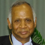
Name of the Speaker: Dr. Shashikant A Sharma
Title of the Seminar: VEDAS: A platform for web-based visualization and analysis of Satellite data
Date and Time: 30 August 2022 (Tuesday), 4:00pm
Online Platform: MS Teams (link to the video of the seminar)
About the Speaker: Shashikant A Sharma, Scientist-G and Group Director, VEDAS Research Group, Space Applications Centre (ISRO), Ahmedabad, India. He joined ISRO in 1986 and has worked in the field of Remote Sensing, GIS, and Digital Image Processing. He has a special interest in applications of Geoinformatics for Agriculture and Renewable Energy. He is instrumental in the development of the Geospatial portal – VEDAS ( Visualisation of Earth Observation Data and Archival System) (https://vedas .sac.gov.in), which has visualization and analysis capabilities of Geospatial data. Earlier he was a lead role in the development of indigenous GIS software.
His current interests are Digital Image Processing, Geospatial analytics on the Web, and AI/ML applications of Satellite data. He is the recipient of many national awards in the field of Geoinformatics.
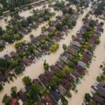
Abstract: ISRO is operating a fleet of Earth Observation satellites with a wide range of sensors of varying capabilities. In addition to making satellites and launch vehicles, ISRO is also conducting scientific research and demonstrating applications of space-based inputs in many disciplines including agriculture, forestry, geology, environmental studies, urban planning, infrastructure development, meteorology, planetary sciences, disaster management, etc. The efficient utilization of this voluminous geospatial content generated by the thematic experts and the data acquired by several Indian and publicly available EO satellites is essential for adding greater societal value as envisaged by Dr Vikram Sarabhai, the founder of India’s space programme.
In this context, the Space Applications Centre at Ahmedabad contemplated the development of the ‘Visualization of EO Data and Archival System’, abbreviated as VEDAS. It aims to organize the vast quantum of geospatial databases on various themes and develop customized decision support systems and applications for an improved understanding of the earth and planetary systems. VEDAS is a step towards creating a “geo-data-rich society” supporting mainstreaming of satellite imagery and remote sensing in the process of National Development.
In this talk, I will provide an overview of the VEDAS, its capabilities and its potential for research and decision-making, while illuminating what lies ahead for us. For example, VEDAS has endeavoured to support web-based geospatial analysis by providing processing tools for analysis on the internet and we are now building an online interactive platform for Big Data analytics and supporting the application of Artificial Intelligence and Machine Learning (AI/ML) tools.
Date/Time
Date(s) - 30/08/2022
4:00 pm